![]()
![]()
| Home | Site Map | FAQ | Links |
|
|
|
| MAPS | ACTIVITIES | LODGING | DINING |
| TRAVEL INFO | REFERENCE | GALLERY | EMPLOYMENT |
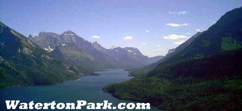
Geology and GeomorphologyWaterton Lakes has some of the oldest exposed sedimentary rock
in the Canadian Rockies (1200 to 1500 million years old). This
rock can be seen at Cameron Falls. Because its rocks were formed
at a time predating the development of most life on earth, few
fossils occur here. Only fossils formed by primitive
cyanobacteria (blue-green algae) are found. Some developed into
impressive cabbage-like fossils of algal colonies called
stromatolites.
GEOLOGY & GEOMORPHOLOGYMany people traveling in the Rockies remark on how different the mountains of Waterton Park and Glacier appear. Most are struck by the vivid colours of the rock, especially the reds and the greens. Our spectacular scenery is based on spectacular geology. Learning how and when the rocks were formed, uplifted and eroded adds a new dimension to our mountain views. The rock layers you see are eroded sediments laid down particle by particle at the bottom of one of many ancient seas which existed in North America. The rock layers exposed in Waterton/Glacier combine to form only one chapter of our planet's 4,600 million year history! Trying to conceptualize the age of the earth is a daunting task. Geologists tackled this problem by creating a calendar breaking down the passage of time into eons, eras, periods and epochs (see below). We can more easily form an idea of the relative duration of the earth's past by comparing it to one year:
The earth experiences many changes to its landforms due to the interaction of water, land, climate, life and crustal movement. Mountain ranges have come and gone, and still do. Viewing mountains, you get the illusion of permanence, when they are actually being eroded and carried away bit by bit. CONTINENTS ADRIFTThe earth's crust is like a cracked shell on a hard boiled egg . Although, if the earth were the size of an egg, its fragile outer layer would be much thinner than an egg shell. These shell pieces, or plates, are tightly interlocked and move very slowly (2 to 7 cm/year) on the hot, nearly molten rock of the mantle. Some of these plates form continents and the rest form ocean floors. Plates shift and collide due to convection currents within the earth's mantle. Where plates move away from each other (rift) - earthquakes occur and the space is filled in with magma that solidifies into new rock. Where plates run into each other - earthquakes, mountains and volcanoes appear. When ocean and continental plates meet, the oceanic plate usually melts and recycles into new rock (subducted) under the continent. When continents collide, huge mountains like Mt. Everest form. EROSION AND DEPOSITIONLand is constantly subjected to weathering and erosion. Weathering is done chemically (by slightly acidic water) or physically (by prying open cracks with freezing water or plant roots). Running water, flowing rivers of ice (glaciers) and wind use transported rock, like sandpaper on wood, to scour the landscape. Rates of erosion vary with elevation, climate and plant cover. Weathered, loose material is transported to lower elevations, then deposited. In this way, rivers and streams have carried sediments like sands, muds, silts and clays to sea coasts. Similarly, Waterton's townsite is built on an alluvial fan, which was formed from large amounts of material carried by Cameron Creek and deposited into the lake. Over many years, layer upon layer of eroded sediments are laid down. The weight of the upper layers compress the lower layers while minerals from ground water cement particles together. Eventually, sedimentary rock is formed. When these sedimentary layers are uplifted, from the moment they are exposed, they are again subjected to the forces of erosion and the cycle is repeated. Mountains can only form when they are uplifted faster then they are eroded. Thousands of feet of rock had already eroded from Waterton's mountains before they reached their present location. THE ROCKS THAT FORM OUR MOUNTAINSIt is thought that a little over 1.5 billion (1500 million) years ago, most of the continents came together at the equator to form a supercontinent called Rodinia. As the continents slowly rifted apart, a depression formed and filled with sea water. Pre-Alberta was next to this sea. The rocks now forming the mountains of Waterton/Glacier were once sediments along the coast of this inland sea, called the Belt Sea. For the hundreds of millions of years that the Belt Sea existed, its floor alternately sank with its sedimentary load and uplifted with plate movement. Its shores advanced and retreated many times. In the absence of land plants, pre-Alberta was a balmy, but barren, place. Changes in the area's climate, water depth and rate of deposition are all recorded in the rock. Around 1300 million years ago, molten rock from the mantle squeezed up through cracks in the sea floor, injecting itself between sedimentary layers (intrusive magma). Some eventually flowed out at the surface as lava. This intrusive and extrusive magma now forms the only igneous rock in Waterton/Glacier - known as the Purcell Sill and Flow. It was the time of flourishing microscopic life, which had not yet ventured out of the sea. For most, day-to-day life involved eating hydrogen sulphide, secreting sulphur, multiplying and eating again. Much earlier, some bacteria had stumbled upon other processes of obtaining food. Proalgae or cyanobacteria (sometimes called blue-green algae) used the sun's energy to split carbon dioxide into carbon and oxygen in a process called photosynthesis. They used carbon and secreted oxygen as waste, polluting the earth's atmosphere with it (the stuff we now breath!) Some of this oxygen eventually formed the ozone layer, which protects the earth's surface from solar ultraviolet radiation. As various species of cyanobacteria created their food, they also changed the water chemistry. This caused a crust of calcium carbonate to form on them. Bacterial filaments broke through the crust and the cycle repeated. Layers of this crust were preserved as fossils. Some species of cyanobacteria formed mucous-covered colonies. Over time the crustal accumulations formed thick, laminated mounds geologists call stromatolites (stoned carpets). Fossilized stromatolites are only abundant in rocks exceeding 500 million years old. Scientists speculate that this is due to a growing population of sea snails! Although rare, stromatolites of today only exist in areas where the snails can't live (e.g. Shark Bay, Australia). Fossilized stromatolites are easily seen in Waterton Park at Red Rock Canyon and in the talus slope before the tunnel on the Crypt Lake trail. Look close, they resemble cabbages cut in half. Meanwhile, huge rivers flowed across the land and poured into the sea. During this era, erosion was immense due to the absence of plant roots to hold things down. For over 600 million years, sediments accumulated at the bottom of the Belt Sea. Layer upon layer of sand, silt, clay and iron-rich mud were buried, compressed and cemented to form the sandstones, siltstones, shales, limestones and dolomites of today. Some deeply buried layers were changed or metamorphosed as a result of additional pressure and heat. Sandstones were changed to quartzite, siltstones were changed to siltite, shales to argillite (red and green rocks) and limestones and dolomites were recrystallized. Evidence of the ancient Belt Sea can be found in casts of ripple marks, mud cracks, salt crystals and algal colonies throughout the park (even on mountain tops). Red Rock Canyon's self-guided trail is a good location to see all of these features. During the time the Belt Sea existed, deposition didn't occur in the Banff and Jasper area. While the rocks of Banff and Jasper were forming later; Waterton/Glacier's rocks were often high and dry. Many seas flooded North America many different times, from many different directions. Younger layers of sediment deposited on top of older sediments have since eroded away. The rocks seen today in Waterton Lakes are between 1200 to 1500 million years old. These were originally deposited 100 km (63 miles) southwest of Waterton Park. So how did they get here? BUILDING A MOUNTAIN RANGEDrill down through the sedimentary layers of the Rocky Mountains and you'll eventually hit granite. This rock forms the "basement" of the North American continent. Below this is rock congealed from the earth's mantle on which the continental plates drift. From space, the Rockies resemble wrinkles at the edge of a rug and this is a good way to visualize their formation. Imagine the layers of sedimentary rock (the rug) lying on top of the continent's basement (the floor). Now think of pushing the edge of the rug and how the rug would wrinkle up (the sedimentary layers shortened or compressed into a narrow band of mountains). All the western mountain ranges were built as a result of the North American plate moving over a now non-existent, oceanic plate beginning 150 million years ago. As the sedimentary layers were compressed, folds began to form. Some of the folds were so compressed they broke and cracks formed (faults). As pressure from the west continued, sections of the rock plate (thrust sheet) was pushed up and over other sections creating a thrust faults. In most of the front ranges of the Rockies, mountains were built as a result of many major faults causing overlapping thrust sheets to pile up on one another, looking very much like shingles on a roof (as seen in Banff and Jasper). The mountains of Waterton/Glacier were formed in a slightly different way. THE LEWIS THRUSTWhat's so different about our mountains? Let's return to our carpet analogy. From space, the front ranges of Banff and Jasper resemble at least six long narrow waves or folds. Each narrow range is underlain by a major thrust fault. Looking from space over Waterton/Glacier there are no linear waves of mountains. Here, the mountains are underlain by one super thrust fault - the Lewis fault. The fault extends from south of Marias Pass in Glacier_N.P. to nearly the Bow River in Banff (approx. 560 km./348 miles). However, most of the horizontal displacement occurred in the Waterton/Glacier area, with movement along the fault dwindling towards each end of the thrust sheet. Starting about 75 million years ago, in an area southwest of today's Waterton/Glacier, the rock layers began to buckle and fold. As pressure from the west continued, the layers cracked. Instead of breaking into smaller fragments and piling into overlapping thrust sheets, it moved more or less as a single, large unit. Roughly at the centre of the Lewis thrust sheet, on its leading edge, were rocks formed in the Belt Sea. Because of it's displacement, these ancient rocks now sat on top of much younger (75 million year old) Cretaceous rock. In Waterton Lakes National Park, where the rock was displaced the furthest, the Lewis thrust sheet moved northeast a distance of 100 km/ 63 miles! This didn't happen overnight - it took about 15 million years! Within the large Lewis thrust sheet, many smaller thrusts and folds were created and carried along as the whole unit moved. For example, Crandell Mountain shows many folds and distortions in its sedimentary layers. The oldest exposed rock layers found in Waterton Park (about 1500 million years old) are called the Waterton formation. This rock can be seen at Cameron Falls. So what happened to the sedimentary layers older than the Waterton formation? As it turns out, the rock didn't fracture all the way through the layers to the granite basement rock. Some layers were left behind. Our mountains left their roots in Montana and British Columbia! In summary, the formation of Waterton/Glacier's mountains started with a fracture in the earth's crust some 75 million years ago. Tremendous internal forces, caused by plates colliding, slowly uplifted a huge slab of rock thousands of feet thick (Lewis thrust sheet) and hundreds of miles long, thrusting it up in a northeasterly direction over younger layers of rock. This rock unit came to rest millions of years and a hundred kilometers later in the Waterton/Glacier area. Much of the rock has since been eroded away both during and after mountain building. What remains are mountains made of old sedimentary rocks, overlying younger rock - creating a range of "rootless mountains". THE DISTINCTIVE FEATURES OF OUR MOUNTAINSWhat sets our mountains apart?
More About The RocksThe light-coloured layers (white, buff, light brown) are limestone and a similar rock called dolomite (in which some calcium has been replaced by magnesium). These rocks form cliffs and steep slopes because they resist erosion better then the crumbly argillites. Reds and GreenThe red and green layers are made of hardened mud called argillite. Both colours came from iron, which shows red in one mineral (hematite, oxidized state) and green in another mineral (chlorite, unoxidized state). Just a three-percent content of iron in these rocks is enough to form their brilliant colour. Purcell SillAlthough most of Waterton's rock is sedimentary, a striking band of igneous rock can be seen. This band, or sill, is a result of molten magma being injected between sedimentary layers. The heat of this intrusion forced out the dark organic matter from the surounding limestone, changing it into white marble (metamorphic rock). The magma cooled very slowly, allowing large star-shaped crystals to form. These phenocrysts can be seen in the dark grey to pale violet gabbro rocks used in some of Waterton's buildings. A band of this igneous rock and marble, looking like striped toothpaste, can be seen stretched across the north face of Mt. Cleveland and other park mountains, such as Mt. Anderson and Mt. Blakiston near Red Rock Canyon. Purcell FlowThe intrusive magma also forced its way to the surface, where it oozed out as a lava flow. It cooled quickly, leaving many small gas-bubbles or holes in the basalt rock. Sometimes these holes were filled with calcium or quartz crystals which precipitated out of groundwater. These dark rocks with small specks of white crystals found in the park are called amygdaloidal basalts. Basaltic rocks without crystals and just holes can also be found throughout the park. Attention rock hounds!Please remember, it is illegal to collect rocks or other natural artifacts in a National Park. Leave them behind for others to look at. GLACIATIONOver the last three million years North America has experienced four major ice ages. These advances and retreats (melt backs) of glaciers were probably initiated by a general cooling of the earth's climate. Although it's common to think of one long ice age, in reality it was interrupted by warmer inter-glacial periods. The last major ice age happened between 10,000 and 12,000 years ago, with a minor advance 4,000 years ago. Currently, glaciers cover about 10 percent of the world's landmass. The Greenland and Antarctic ice sheets account for 96 percent while mountain glaciers account for the remaining 4%. Glaciers exist where more snow falls in winter than melts in summer. Snow that remains from year to year compacts down into hard snow (firn) and ice. Under tremendous pressure, the ice recrystallizes, deforms and given the right conditions, flows like thick molasses. Snowpatches and snowfields are isolated patches of perennial snow without the mass or slope for movement. A glacier flows. Today, Waterton Park supports a few snowpatches while Glacier N.P. supports several snowfields and about 50 small glaciers. Two types of glaciers sculpted the Waterton/Glacier landscape - mountain (Cordilleran) glaciers and the continental (Laurentide) ice sheet. Only during the first and most extensive ice age did Laurentide ice reach the east flanks of the park. The erosive power of glaciers was immense. As a glacier flows, it drags rocks, boulders, pebbles, sand and silt across bedrock cutting away at it like a great rasp or file. Deep lakes are dug (eg. Upper Waterton). River bottoms are broadened and deepened (eg. U-shaped Blakiston valley). Valleys are left hanging (places where smaller glaciers piggybacked onto larger glaciers) (eg. Cameron Falls). Rock ridges are sharpened (eg. citadel peaks) and cirques are back quarried (eg. Cameron Lake). The turquoise colour of some mountain lakes results when fine rock dust washes into the water and reflects the sunlight. Glaciers also transport and deposit huge amounts of material. Like a conveyor belt, eroded material is carried from one place and dumped (melted out) on another. This material is deposited by glaciers directly as moraines or it is deposited by meltwater on the ice (kames), in the ice (eskers), or away from the ice (outwash plains). In Waterton Lakes National Park, most of these features were laid down in the northeast part of the Park, outside the mouth of the Waterton and Blakiston Valleys. Some features, like alluvial fans, are still being added on to. A good example is the fan the townsite of Waterton sits on. It formed when the meltwaters of Cameron Valley glaciers carried sands, gravel and other debris into Upper Waterton Lake. Spring meltwaters still carry large amounts of debris in similar fashion. As water flows past Cameron Falls, its velocity drops. Slower moving water can't carry as much debris so much is dropped out. In heavy runoff years, creeks jump their banks and form a new channel. Through consecutive flooding, the creeks move back and forth, depositing material to form the typical fan shape. This process can create problems in the townsite. As a result, Cameron Creek's banks were stabilized with rock gabions. All other creeks and fans (eg. Bertha and Blakiston [the park's largest]), are left to natural processes. For tens of millions of years this landscape was sculptured by rivers, streams and creeks. In a relatively short amount of time, fingers of ice reworked the landscape. Today, water continues to change the land. Will the glaciers return? ReferencesAlt. David D. And Donald W. Hyndman. 1978. Rocks, Ice and
Water. Mountain Press Publishing Company, Missoula, Montana, USA. |