![]()
![]()
| Home | Site Map | FAQ | Links |
|
|
|
| MAPS | ACTIVITIES | LODGING | DINING |
| TRAVEL INFO | REFERENCE | GALLERY | EMPLOYMENT |
Frank Slide & Crowsnest Pass, Alberta, Canada |
 |
 |
|
Frank Slide Interpretive Centre - Displays
illustrate the disastrous 1903 Frank Slide, railroad
building, European settlement, early coal mining and
community life. Dynamic multimedia presentations include the
award-winning film, "In the Mountain's Shadow".
Trails around the centre provide spectacular views. Bellevue Mine Tour - Equipped with a hard hat and
miner's lamp, visitors follow their guide to enter the
fascinating world of an underground coal mine through
approximately 100 meters of the mine's main rock tunnel, and
into 200 meters of the coal seam itself. Crowsnest Museum - Story of the Crowsnest Pass
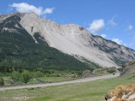
from 1899 to 1950. Crowsnest Pass Ecomuseum - The Crowsnest Pass is
the home of the worst mine disaster in Canada, the Frank
Slide, labour confrontations, prohibition-era bootleggers,
train robbers, shoot-outs, and hangings. Location: 13437 -
20 Ave., Blairmore Leitch Collieries Provincial Historic Site - One
of the most sophisticated early coal mining operations.
Displays explain the coal extraction process used from 1907
to 1915. Interpretive trails lead past the mine manager's
residence and coke ovens. Allison Creek Brood Trout Station - Brood stock
station for brook, brown and rainbow trout eggs. Burmis Tree - This rare Limber Pine is one of the most famous and most photographed trees in Alberta. Located on the roadside along Hwy. 3 in the Lundbreck-Burmis area, 11 km (6 mi.) E of the Frank Slide Interpretive Centre. Livingstone Gap - A dramatic break in the rock of
the Livingstone Mountain Range. The Oldman River plunges
through the narrow gorge from mountains to the surrounding
prairie. Livingstone Falls - Livingstone River rushes over a gently sloping rock face, creating these picturesque falls. Location: 65 km (40 mi.) N of Hwy. 3 on Hwy. 940 Lundbreck Falls - The Crowsnest River plunges 12
meters (39 ft) to the canyon below. Camping and picnic
facilities.
|